Weather Routing finds the fastest passage for your boat between two points, from the forecast wind. It routes every passage on three wind models at once, GFS, ECMWF, and AIFS, so you can see where they agree. It’s part of OceanPulse Elite, and it needs a data connection.
Open Weather Routing#
In the sidebar, under Tools, tap Weather Routing. The Route Planner card sits over the chart.
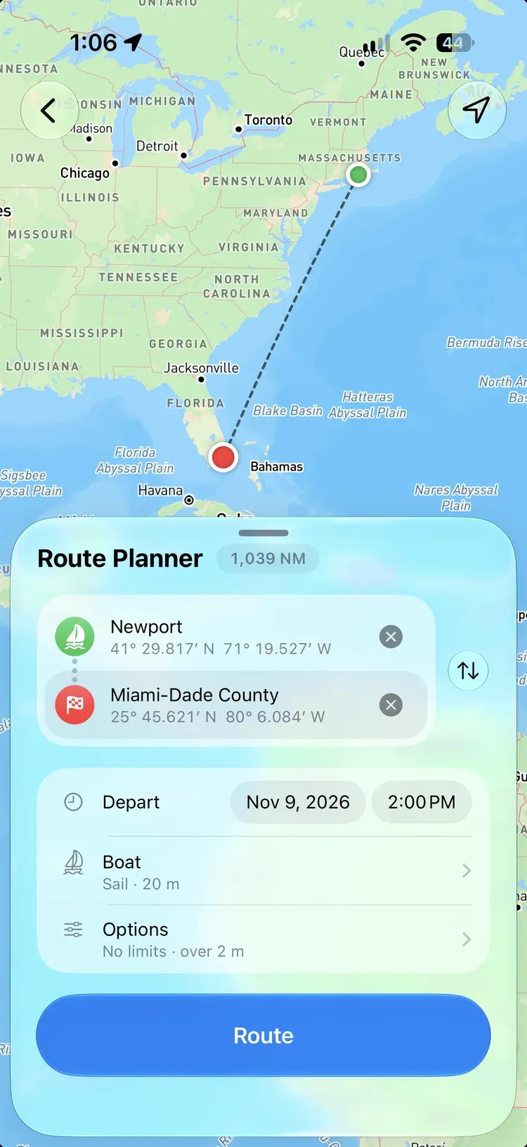
Plan a passage#
- Start: tap the chart where you’re leaving from. Or tap the Start row for Start from My Location or Search for the Start, which finds places, marinas, your markers, and tide stations, as the chart’s search does.
- End: tap the chart again where you’re going, or use End at My Location or Search for the End.
- Depart: choose when you’ll leave, from three hours ago up to ten days ahead. It starts on the next whole hour.
- Tap Route.
Drag either end on the chart to move it, or tap Swap Start and End to route the other way. An end on land or in a harbour moves out to open water nearby, and the route draws a dotted line to it.
A passage can be from 1 to 4,000 NM long.
Watch the models race#
When you tap Route, the chart shows both ends while the forecasts are read, then a line for each model grows from the start as it’s worked out. Each model’s row counts up the miles as it goes. When a model finishes, its route takes the place of its line.
Most passages take under a minute. Tap Cancel to stop and go back to your ends. If your connection drops, OceanPulse joins the passage again while it’s still routing.
Your boat#
Tap Boat in the Route Planner to open the Vessel screen. Routes use:
- Type: Sail or Power, and the Hull: Monohull or Catamaran.
- Dimensions: Length, Waterline, Draft, and Air Draft. Leave the waterline blank and it’s taken from the length.
- Engine: Cruise Speed, for a power boat, and for a sailboat motoring in light air.
- Polar: a sailboat starts on a generic polar. Tap Import Polar File… to use your boat’s own: a text table with true wind angles down the side and wind speeds across the top, as LuckGrib, Expedition, qtVlm, and OpenCPN read it. Performance sets how close to the polar you sail, from 60 to 100%; cruisers typically sail at 80 to 90%.
- Advanced: Closest to the Wind, Deepest Downwind, and Time Lost per Tack for a sailboat, and how waves slow the boat under engine.
Route options#
Tap Options in the Route Planner:
- Comfort Limits: the most Wind, Gusts, Apparent Wind, and Waves you’ll take. Routes go around weather over your limits. Each starts at No Limit.
- Light Air: with Motor in Light Air on, routes motor at your cruise speed when the wind is under your Minimum Sailing Wind (2 to 10 kt). Turn it off and routes wait for wind when it falls calm.
- Shallow Water: Keep to Depths Over 2, 3, 5, or 10 m (or the same in your units). Offshore, routes keep out of water shallower than this at chart datum.
- Charted Areas: Avoid Bridges and Cables With No Charted Clearance, and Avoid Sparsely Sounded Water. Both start off.
Near shore#
In US waters, where NOAA charts cover both ends of the passage, routes run on the charts. Your draft decides how shallow they go, and your air draft which bridges and overhead cables they pass under:
- A bridge or cable charted too low for your air draft is closed.
- One with no charted clearance is passed with a warning, unless you turn on Avoid Bridges and Cables With No Charted Clearance.
- Rocks and wrecks of unknown depth are always avoided.
Everywhere else, routes keep off the land and out of water shallower than your Keep to Depths Over depth. That depth data doesn’t show bridges, rocks, or wrecks, so check the route against the chart.
What the routes use#
- Wind: GFS, ECMWF, and AIFS. Every passage routes on all three.
- Currents: Mercator, which includes the tide, then ECMWF Ocean once Mercator’s forecast ends. Currents push the boat along or hold it back, and the sails feel the wind over the moving water.
- Waves: ECMWF WAM, for your Waves limit, the warnings, and slowing the boat under engine.
- Past the forecast: when a passage outlasts the forecast, it sails on with NOAA’s long-range CFS wind, up to 60 days from departure. That wind shows the weather the season allows rather than a forecast, with no gusts or waves, and the route’s warnings say where it starts.
Read the results#
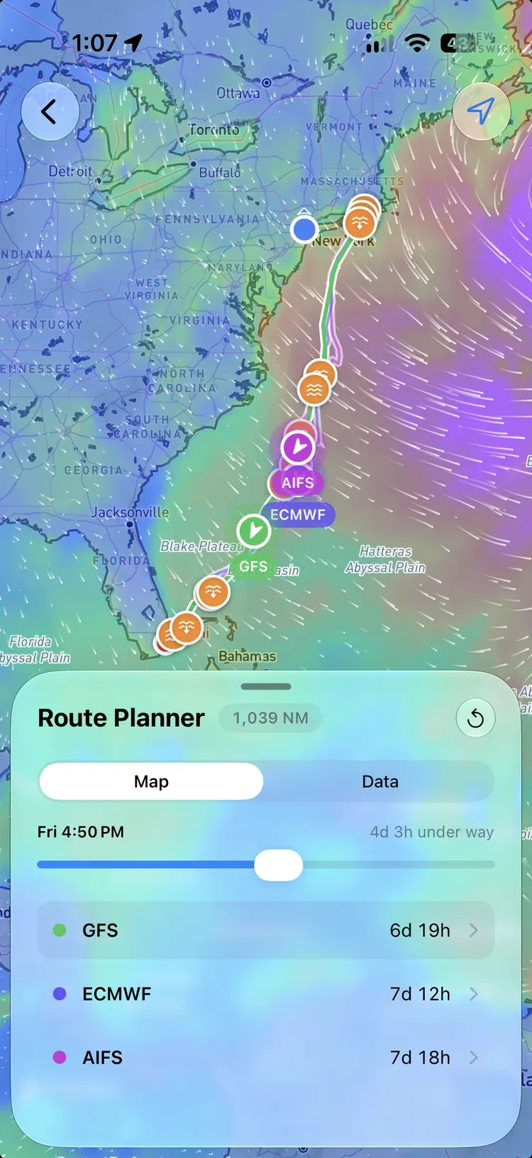
Each model’s route is drawn in its own colour, the fastest on top, with a row for each showing its time at sea. Tap a line to bring it to the top.
- Drag the time scrubber to move the boats and the wind along every route together.
- A route the forecast runs out on is drawn as far as it reached, then dotted to the end. Its row says how far is left.
- Map and Data switch between the chart and the route’s data. Tap a model’s row to open its data.
Data#
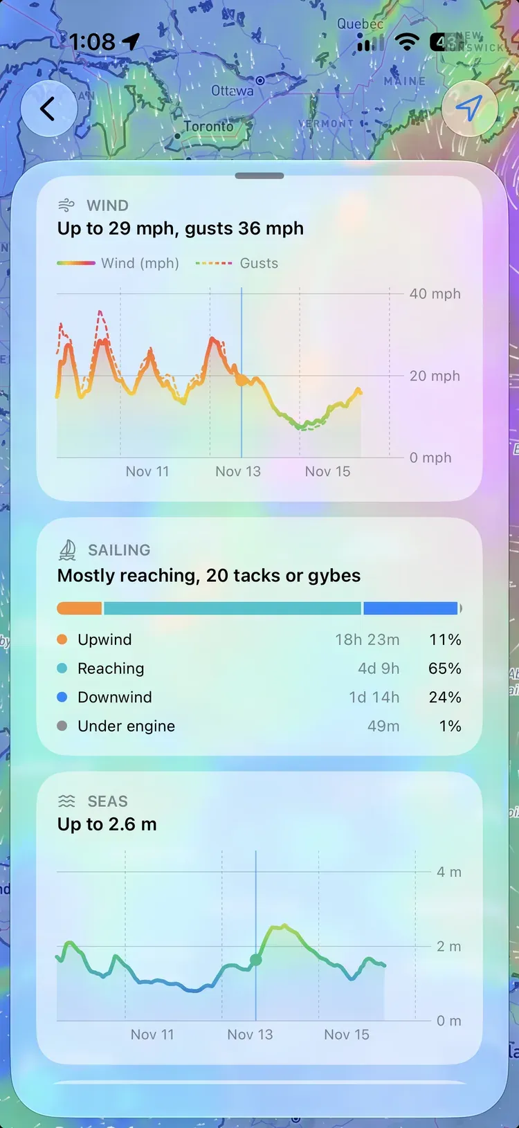
Model picks which route you’re reading. Then:
- Arrives (or Forecast ends), the time at sea, Distance, Average speed, and time under Engine.
- Watch Out: wind, gusts, apparent wind, or seas over your limits, wind against current, shallow water, caution areas, traffic separation schemes, poorly surveyed water, and where the route runs past the forecast. Tap a warning to see it on the map.
- Wind and Seas charts for the whole passage.
- Sailing: how much of the passage is upwind, reaching, downwind, under engine, or becalmed.
- Hour by Hour: a table of every hour’s wind, boat, waves, current, weather, and chart, in folding sections.
- Export as CSV: the same hours as a spreadsheet, one row per hour, in UTC.
Tap New Passage to start again.